The Digital Orthophoto is an image map produced by the SMO that provides visual representation of ground features extracted from geometrically rectified aerial photographs. It is characterized by its use of the Hong Kong 1980 Grid system for coordinate reference and a consistent scale for accurate representation. Through the application of digital photogrammetry technology, the rectification process aims to eliminate geometric distortions caused by topographic relief and camera tilt present in the original aerial photographs.
Currently, the Digital Orthophoto consists of six distinct series of products: DOP5000, DOP5000-1982, DOP1000-1963, DOP1000-1976, DOP1000-1982, and TDOP. These series are classified based on factors such as image resolution size, types of source photographs, and the specific orthophoto processing techniques employed. The resulting orthophotos are stored in the GeoTIFF image formats, accompanied by geo-referencing data in a World format.
The Digital Orthophoto is primarily prepared in the style of conventional orthophotos, which means that rectification for topographic relief is applied solely to ground features, elevated roads, and bridges. However, the True Digital Orthophoto (TDOP) series takes a different approach. TDOP rectifies all physical features, including buildings, through the utilization of the true orthophoto processing method.
DOP5000 SERIES
There are currently two products in this series namely DOP5000 and DOP5000-1982.
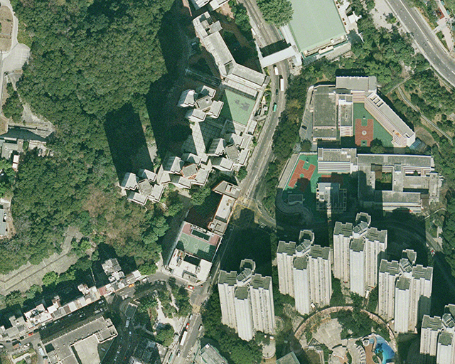
The DOP5000 has an image resolution of 0.2m in terms of ground sample distance per pixel covering the whole territory of Hong Kong Special Administrative Region. It is compiled mainly from the recent aerial photographs taken at various flying heights (from 2,000 ft. to 9,000 ft). Unlike land areas, sea areas are not fully covered by aerial photographs. Therefore, some sea areas as shown on DOP5000 are produced by duplicating a similar image. DOP5000 is commonly used as a 1:5,000 map for general purpose by the architects, engineers, planners, developers, etc. It is supplied on tile basis and each tile is equivalent to the coverage of the corresponding 1:5,000 topographic map tile. A full set of DOP5000 has 192 tiles. It is provided in GeoTiff format on tile basis including a world file with geo-referencing data in Hong Kong 1980 Grid. The data file size of each tile is about 810MB. (see Map Reference and Data Updateness for latest information).

Portion Image of DOP5000 Image
DOP5000-1982 with ground sampling distance of 0.3m were produced from aerial photos taken in October of 1982 at flying height of about 10,000 feet. It consists of 182 tiles of images provided in GeoTiff format on tile basis including a world file with geo-referencing data in Hong Kong 1980 Grid. The data file size of each tile is about 125MB. It can be used as a 1:5,000 map showing the old ground features in 1982. Areas without suitable aerial photographs are shown in white on the orthophoto.

DOP5000-1982 Orthophoto Data Index
DOP1000 SERIES
The DOP1000 Series has an image resolution of 0.1m in terms of ground sample distance per pixel. There are currently three products in this series namely DOP1000-1963, DOP1000-1976, and DOP1000-1982.
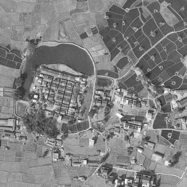
DOP1000-1963 is using mainly aerial photographs of an approximate photo scale of 1:8,000 taken at a flying height of about 3,900 ft. in January/February of Year 1963. It covers most of the Hong Kong land areas including the New Territories, Kowloon and Hong Kong Island except some places, including the border areas, Ping Chau and a few hill tops, where suitable 1963 aerial photographs are not available.
DOP1000-1976 is produced using aerial photographs taken in January, June, and August of 1976 at a flying height of about 4,000 feet. It primarily covers Hong Kong Island, and partially includes areas such as Yau Tsim Mong, Kowloon City, Wong Tai Sin, Kwun Tong, Kwai Tsing, Tsuen Wan, Tuen Mun, Yuen Long, Tai Po, Sha Tin and Sai Kung.
DOP1000-1982 is produced from aerial photographs taken in May, July, August, October, November and December of Year 1982 at flying height of about 4000 ft. It is covering Hong Kong Island, Kowloon, Yuen Long, North, Tuen Mun, Tsuen Wan, Kwai Tsing, Sai Kung, Tai Po, Sha Tin and Islands Districts. This limited coverage is due to the inadequacy of 1982's aerial photographs.
Areas without suitable aerial photographs are shown in white on the orthophoto. For some ground features having a drastic change of elevation, e.g. a cliff, their images will have a smearing appearance due to insufficient data, which is a commonly encountered issue in producing a high resolution orthophoto.
DOP1000-1963, DOP1000-1976, and DOP1000-1982 can be used for various applications requiring identification of old ground features. One common example is that it can be used as a survey map at a scale of 1:1,000 to supplement use of the original aerial photographs and DD sheets in conducting land boundary correlation exercise.
DOP1000 Series are supplied on tile basis and each tile is equivalent to the coverage of the corresponding 1:1,000 topographic map tile. Currently, two versions of the orthophoto are provided, i.e. the plain image version and the grid line version.

DOP1000-1963 Orthophoto Data Index

DOP1000-1976 Orthophoto Data Index

DOP1000-1982 Orthophoto Data Index
")
Plain image version of DOP1000-1963 Orthophoto (Tile no. 6-NW-4A)
")
Plain image version of DOP1000-1976 Orthophoto (Tile no. 6-NW-4A)
")
Plain image version of DOP1000-1982 Orthophoto (Tile no. 6-NW-4A)
TDOP SERIES
True Digital Orthophoto (TDOP) Series is produced from Digital Aerial Photos (UE Version) which are taken at flying height of about 13,000 feet, and processed using Digital Surface Model. The TDOP has an image resolution of 0.25m in terms of ground sample distance per pixel covering the whole territory of Hong Kong Special Administrative Region. The production of TDOP is highly automatic, image distortions might appear at some areas of the True Digital Orthophoto such as area around tall structures, shadows, narrow gaps, features mixed with vegetation and water bodies.
The TDOP Series is supplied on tile basis and each tile is equivalent to the coverage of the corresponding 1:5000 topographic map tile. It consists of 192 tiles provided in GeoTIFF format including a World file with geo-referencing data in Hong Kong 1980 Grid. The data file size of each tile is about 520MB. (see Map Reference and Data Updateness for latest information)

TDOP Data Index
PRODUCT SPECIFICATIONS
The six series of Digital Orthophoto are all available for sale to the public (see Ordering and Data Charge for details). Their product specifications are as follows:
Enquiries
For sales enquiries Tel.: 2231 3187 or Email: smosale1@landsd.gov.hk
For technical enquiries Tel.: 2231 3187 or Email: dss@landsd.gov.hk
Photography Date of DOP5000 Digital Orthophotos (CSV)
Photography Date of TDOP True Digital Orthophotos (CSV)
The Digital Map is stored as a continuous and seamless map base, and is referenced in tiles. Each tile is referenced in the same manner as the paper map counterpart, e.g. 11-NE-1A for a particular 1:1000 topographic map and sheet 11 for a 1:20000 topographic map.
Download Sheet Index of:
(All the following document files are in PDF format)
