3D Digital Map
Under Government policies and initiatives, the Smart City Blueprint for Hong Kong released in December 2017 set out the overall framework and strategy for developing Hong Kong into a spatially enabled smart city including the adoption of Building Information Modelling (BIM) and the development of Common Spatial Data Infrastructure (CSDI) and 3D Digital Map.
The 3D Digital Map, which is one of the major datasets of CSDI, is to facilitate opening up and sharing of Government geospatial data. To meet the increasing needs of 3D Digital Map applications and enhance better understanding of multi-level spaces of a modern city like Hong Kong, the Government aims to develop the high-quality 3D Digital Map by phases and strives to cover the whole territory.
Lands Department is responsible to explore the 3D mapping technology and to implement the territory-wide 3D digital mapping project.
3D Visualisation Map
The 3D Visualisation Map (Individualised models) are a set of digital data of 3D models featuring geometry models and texture maps to represent the geometrical shape, appearance and position of different types of ground objects, including building, infrastructure, vegetation, site, waterbody, terrain and generic (others). The dataset covers the entire territory of Hong Kong. You can access the 3D Visualisation Map on the online application platform "Open3Dhk", or download the dataset through the Common Spatial Data Infrastructure Portal.
The 3D Visualisation Map (Non-textured models) are a set of digital data of 3D models featuring geometry models to represent the geometrical shape and position of different types of ground objects, including building, infrastructure and terrain. The dataset covers the whole territory of Hong Kong. You can access the 3D Visualisation Map on the online application platform "Open3Dhk", or download the dataset through the Common Spatial Data Infrastructure Portal.
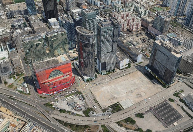
The 3D Visualisation Map (Tile-based models) are based on the mesh model made from oblique aerial images. The dataset covers the entire territory of Hong Kong. You can access the 3D Visualisation Map on the online application platform "Open3Dhk", or download the dataset through the Common Spatial Data Infrastructure Portal.
3D Indoor Map
Lands Department conducts pilot project to generate 3D Indoor Map covering 1,250 buildings of Hong Kong, Kowloon, New Territories and Islands.
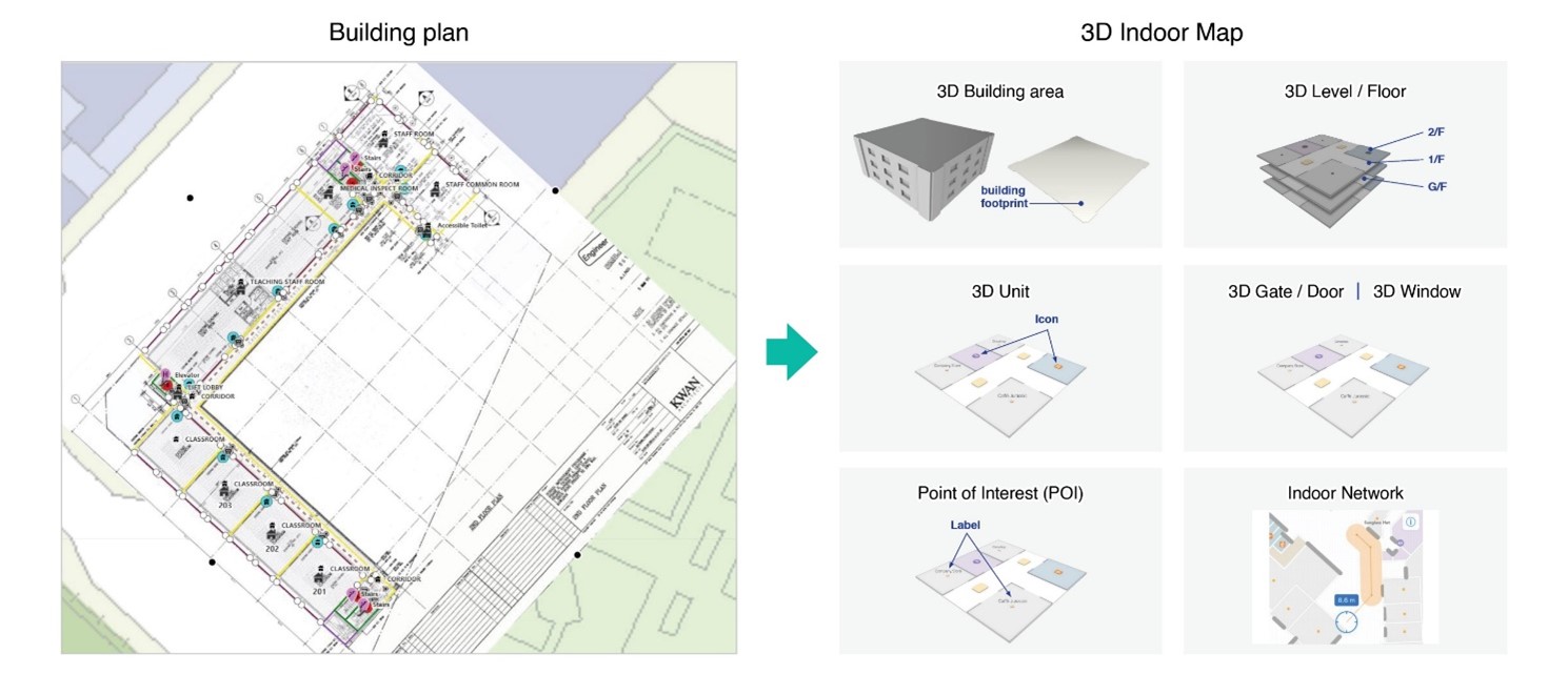
The 3D Indoor Map empowers the 3-dimensional interior layout of a building with GIS-enabled capabilities for 3-dimensional visualization, asset management, tourism and smart applications.
To integrate with Lands Department's 3D Visualization Map and 3D Pedestrian Network, the 3D Indoor Map features precise dimension, floor locations, units, point-of-interests. It also includes entry and exit points, providing an immersive experience of indoor simulations. Additionally, it captures look and feel of the outdoor environment for a comprehensive view.
The 3D Indoor Map transforms traditional floor plans into a digital format, enabling the organization to plan and utilize indoor space effectively. Its dynamic and interactive representation not only simplifies wayfinding, but also enables the demonstration of the indoor environment through technology like augmented reality, virtual reality or extended reality.
3D Pedestrian Network
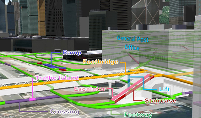
In line with the Smart City initiative of promoting walkability and connectivity, the 3D Pedestrian Network has been designed to support navigation services and accommodate the needs for people with disabilities.
The dataset in machine-readable formats are now available for preview and download on the CSDI Portal and the Open Data Portal.
3D Pedestrian Network
3D Spatial Data (Series: 3D-BIT00)
3D Spatial Data is a set of territory-wide digital 3D model data created to represent the shape, appearance and position of various types of ground features including building, infrastructure and terrain. In this dataset, the 3D models are categorized into seven secondary classes under three primary classes according to their types and level of details as illustrated in the diagram below. The 3D Spatial Data is very useful for many 3D modeling applications such as view analysis for land assessment, 3D animation for presentation of engineering proposals, air ventilation analysis, etc.
For more about the 3D-BIT00 data, you can refer to the Information Sheet on 3D Spatial Data.
Revision Date of 3D-BIT00 3D Spatial Data (CSV)
| Product | Format | |||
|---|---|---|---|---|
|
3ds
|
FBX
|
Max
|
VRML
|
|
| 3D-BIT00 |
✓
|
✓
|
✓
|
✓
|
The Hong Kong Digital Map is supplied to the customers at a charge which is calculated according to the current Price List published by the Government.
Please visit Hong Kong Map Service 2.0 for browsing, downloading or ordering Government Digital Maps.
| For Government Department |
|---|
| Tel: 2231 3454 |
| Fax: 2116 0774 |
|
| For Public |
|---|
| Tel: 2231 3187 |
| Fax: 2116 0774 |
| 3D-BIT00 3D Spatial Data |
Download
|
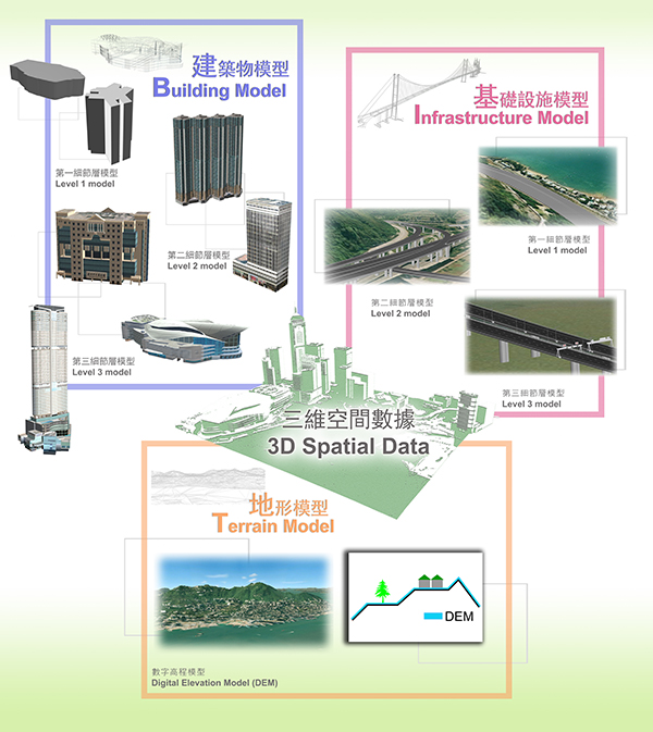
Illustrating Different Classes of 3D Spatial Data

A view of Hong Kong Island Generated Using 3D Spatial Data
Vehicle-based Mobile Mapping System
In 2017, Lands Department introduced the Vehicle-based Mobile Mapping System, which comprises 3D laser scanner, spherical cameras, GNSS receiver, inertial navigation system and distance measurement indicator mounted on a vehicle. This system can efficiently acquire point cloud data and street-view imagery data for various survey and mapping applications, such as recording topographical information, updating the basic map, producing street view map, 3D digital map, and 3D models with very high level of details. This system provides useful spatial data for the development of the Smart City of Hong Kong. You can view the 360-degree street-level panoramic images covering Hong Kong Island, Kowloon, Lantau and the New Territories with the "Streetscape 360" function on the online application platform "Open3Dhk".


