

Hong Kong GeoCode (HKGCode)
Hong Kong GeoCode is a location code publicly launched by the Survey and Mapping Office of the Lands Department in 2026. It is intended to use short, easy-to-read alphanumeric codes to accurately express geographic locations within Hong Kong. Each code consists of three groups of two characters, for a total of six letters or digits. The minimum level can represent locations with a maximum precision of a 5 m × 5 m area.
Introduction Video of Hong Kong GeoCode
Explanatory Notes of Hong Kong GeoCode
Hong Kong GeoCode is based on the Hong Kong 1980 Grid Coordinate System (HK80), adopting a southwest origin with a false origin offset of 800000 Northing and 800000 Easting to define the coverage area. The Hong Kong GeoCode uses a layered grid structure:
- Region Level: Divided into 32 × 24 large grids. Each large grid is 2 km × 2 km, giving a total coverage of 64 km (east) × 48 km (north).
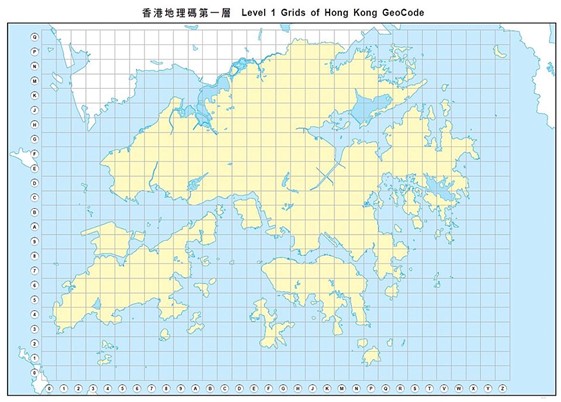
Level 1 Grids of Hong Kong GeoCode – Region Level
- Site Level: Each large grid (Region Level) is further divided into 20 × 20 medium grids, with each medium grid sized 100 m × 100 m.
- Standard level: Each medium grid (Site Level) is further divided into 20 × 20 small grids, with each small grid sized 5 m × 5 m.
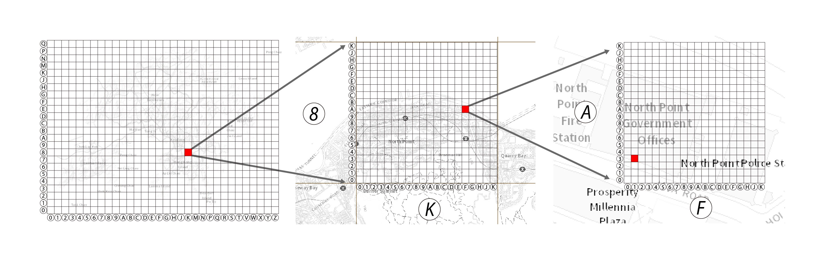
each large grid is 2 km × 2 km
each large grid is 100 m × 100 m
each small grid is 5 m × 5 m
Conversion from HK1980 Grid Coordinate System to Hong Kong Geocode
Hong Kong Geocode is derived directly from the Hong Kong 1980 Grid Coordinate System (Easting E, Northing N, in metres). The encoding uses a character set similar to Crockford Base32, consisting of 0 – 9 and A – Z, excluding I, L, O, and U to avoid confusion with 1 and 0. Characters are used to indicate the eastward (X) and northward (Y) positions. The code is structured from coarse to fine in nested layers: two characters for the Region Level, four characters for the Site Level and six characters for the Standard Level. The large grid at the southwest corner is coded as “00” and the large grid at the northeast corner is coded as “ZQ”.
Character Cross-reference Table(Crockford Base32)
| Numerical Value | Character |
|---|---|
| 0 | 0 |
| 1 | 1 |
| 2 | 2 |
| 3 | 3 |
| 4 | 4 |
| 5 | 5 |
| 6 | 6 |
| 7 | 7 |
| 8 | 8 |
| 9 | 9 |
| 10 | A |
| 11 | B |
| 12 | C |
| 13 | D |
| 14 | E |
| 15 | F |
| Numerical Value | Character |
|---|---|
| 16 | G |
| 17 | H |
| 18 | J |
| 19 | K |
| 20 | M |
| 21 | N |
| 22 | P |
| 23 | Q |
| 24 | R |
| 25 | S |
| 26 | T |
| 27 | V |
| 28 | W |
| 29 | X |
| 30 | Y |
| 31 | Z |
Examples
Region Level(2 km × 2 km)
- Tai O: 16
- Kai Tak: KA
- Ping Chau: ZP
- Po Toi: P1
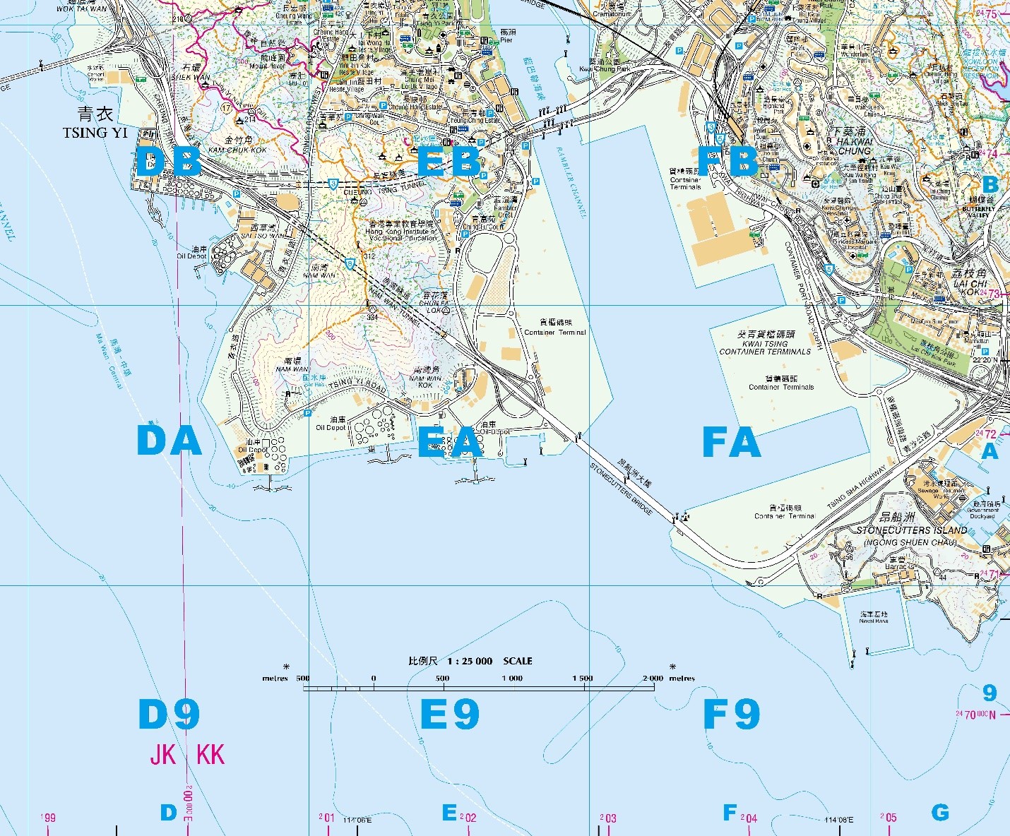
Region Level - Countryside Map with Hong Kong GeoCode
Site Level (100 m × 100 m)
- Hong Kong Space Museum:H8HC
- Hung Hom Ferry Pier:J8FK
- Sai Kung Community Centre:QD2C
Standard Level(5 m × 5 m)
- Former Kowloon-Canton Railway Clock Tower:H8FB2H
- Obstacle Light in Tsing Yi:EA4K4H
- Trigonometrical Station at Sharp Peak:WG73JD
- Main Entrance of the North Point Government Offices:K8FA13
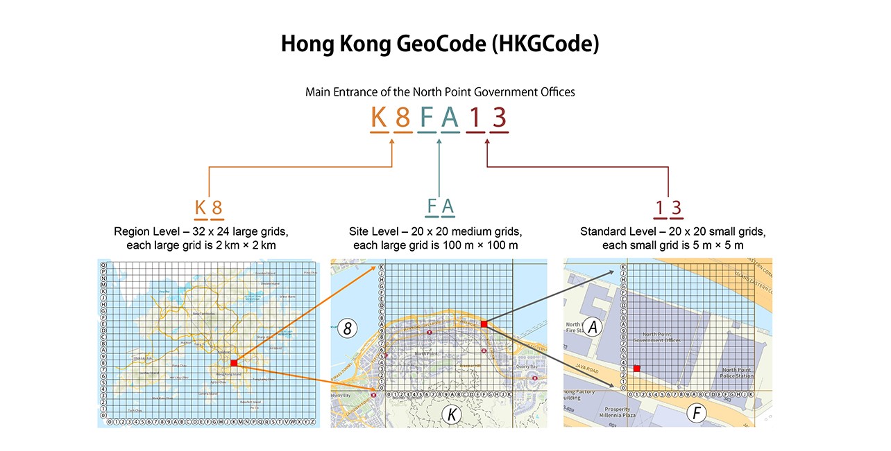
Standard Level - Main Entrance of the North Point Government Offices
Uses and Features
Hong Kong GeoCode can express a precise location with just a few characters, without relying on complex latitude/longitude or grid-coordinate. Its design goals include: providing location code that is easy to read, easy to remember and suitable for public use; supporting cross-platform and device-friendly sharing of locations and facilitating locating, communicating location information and the collection and processing of spatial data. The code uses a layered structure, allowing users to choose an appropriate accuracy level as needed balancing convenience and precision.
Potential Applications
- Location Communication
- Geographic Data Collection and Statistics
- Logistics and Transportation
- Rescue
- Asset Management
- Low-altitude Economy
Hong Kong GeoCode Conversion API (Beta Version)
A trial version of API endpoint supporting Hong Kong GeoCode conversion is now available. For details, please refer to User Manual for Hong Kong GeoCode Conversion API.


