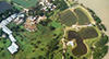
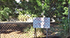
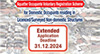
Land Sale
Conditions of Sale, Form of Tender, Tender Notice, Information Statement (if applicable) and Technical Schedule (if applicable) in English portable document format (PDF), sale plan (in both PDF and computer-aided design file (in DWG/DGN format)) and video (if applicable) in MP4 format may be downloaded subject to the following Legal Notices and Disclaimer :
LEGAL NOTICES
PLEASE READ THESE TERMS CAREFULLY BEFORE USING THIS WEBSITE
Lands Department reserves the right to make amendments to and update the materials on this website including but not limited to the Conditions of Sale, the Form of Tender, the Tender Notice, the Information Statement (if applicable), the Technical Schedule (if applicable), the sale plan and the video (if applicable) in respect of an individual site at any time. You should refer to the most updated version (including any amendment and update) uploaded to the website for information.
The sale plan in DWG/DGN format is not intended to provide more information on the sale site. Such plan is provided for reference only and should not be used or relied upon for any precise measurement.
The video (if applicable) shows the aerial views and street views of the sale site. It is not intended to provide more accurate information on the sale site or the most updated information on the surrounding area of the sale site. The video provides a verbal narrative of information of the sale site and visual highlights of some of the Special Conditions in the Conditions of Sale. Such video is provided for reference only. No guarantee or warranty is given as to the adequacy, accuracy or completeness of the information provided by the video.
The sale plan in DWG/DGN format and the video (if applicable) shall not form part of the Conditions of Sale, the Form of Tender, the Tender Notice, the Information Statement (if applicable), the Technical Schedule (if applicable) and the sale plan in PDF format nor shall them be taken into consideration in the interpretation or construction of the Conditions of Sale. You should refer to the most updated version of each of these documents for information.
These materials are provided by Lands Department as a service to the public and may be used for informational purposes only. Materials can be downloaded subject to the terms below (hereinafter called “these terms”).
By downloading any materials from this website, you agree to these terms. If you do not agree to these terms, do not use this website or download any materials from it.
LICENCE: You may download the materials found on Lands Department website (hereinafter called “the Materials”) on a single computer for your personal, non-commercial internal use only. This is a licence, not a transfer of title, and is subject to the restrictions that you will not (a) modify the Materials or use them for any commercial purpose, or any public display, performance, sale or rental; nor (b) transfer the Materials to another person. You agree to prevent any unauthorized copying of the Materials.
OWNERSHIP OF THE MATERIALS: The Materials may not be copied, reproduced, modified, published, uploaded, posted, transmitted, or distributed in any way, without the Government’s written permission.
TERMINATION OF THIS LICENCE: Lands Department may terminate this licence at any time if you are in breach of these terms. Upon termination, you must immediately destroy the Materials.
DISCLAIMER: THE MATERIALS ARE PROVIDED “AS IS” WITHOUT ANY EXPRESS OR IMPLIED WARRANTY OF ANY KIND INCLUDING WARRANTIES OF MERCHANTABILITY, NONINFRINGEMENT OF INTELLECTUAL PROPERTY RIGHTS, OR FITNESS FOR ANY PARTICULAR PURPOSE. IN NO EVENT SHALL LANDS DEPARTMENT BE LIABLE FOR ANY DAMAGES WHATSOEVER (INCLUDING, WITHOUT LIMITATION, DAMAGES FOR LOSS OF PROFITS, BUSINESS INTERRUPTION OR LOSS OF INFORMATION) ARISING OUT OF THE USE OF OR INABILITY TO USE THE MATERIALS, EVEN IF LANDS DEPARTMENT HAS BEEN ADVISED OF THE POSSIBILITY OF SUCH DAMAGES. BECAUSE SOME JURISDICTIONS PROHIBIT THE EXCLUSION OR LIMITATION OF LIABILITY FOR CONSEQUENTIAL OR INCIDENTAL DAMAGES, THE ABOVE LIMITATION MAY NOT APPLY TO YOU.


 Applications and Services
 Coming Events

")


")


